Back
Top Areas
Other Areas
- Middlesex
- Muskoka
- Bruce
- Hastings
- Grey County
- Parry Sound
- Leeds and Grenvi
- Northumberland
- Frontenac
- Renfrew
- Kawartha Lakes
- Haliburton
- Peterborough
- Huron
- Stormont, Dund
- Lanark
- Prescott and R
- Elgin
- Prince Edward
- Lennox & Addin
- Oxford
- Nipissing
- Brantford
- Lambton
- Haldimand
- Cochrane
- Perth
- Brant
- Norfolk
- Timiskaming
- Chatham-Kent
- Sudbury
- Algoma
- Manitoulin
- Thunder Bay
- Greater Sudbur
- Kenora
- Essex
- Leeds & Grenvi
- Rainy River
- Haldimand-Norfolk
Sell Your Home

Shortlisted Properties
- New Homes
- For Sale
- For Rent
Danger! Indicates a dangerous or potentially
negative action.
Error
Maximum 4 project can be compared at one go.
Neighborhood Overview
Applewood, Peel
- Sale : 1096465 - 3000000
- Rent : 2000 - 2150
Applewood, Peel Neighbourhood Overview
Applewood is located in south east Mississauga. It is a few minutes’ drive from major hubs like the city of Toronto and Mississauga City Center. The streets of applewood are named after the families from the first settlers in the area. The first settlers include Church, Haines, Graham, Stewart and Hedge families. Apples were heavily included in business and hence the name.
Applewood is surrounded by Cawthra Road to the west, North service road to the south, Queensway Road to the north and Dixie Road to the east. Therefore, applewood provides easy connectivity with the neighbouring areas. Also, Apple Press is a quarterly newsletter that is published to keep residents up to date with the ongoings of the area.
Buildings in Applewood


Liveability and Lifestyle of Applewood
Applewood has a liveability score of 83. It is ranked 24th in Mississauga and 796th in Ontario. Applewood ranks better than 98% of the areas. These are the figures for the Applewood neighbourhood.
| Liveability | 83 |
| Amenities | A+ |
| Cost of living | C- |
| Employment | C- |
| Housing | B+ |
| Schools | B |
The crime rate in Applewood is 25% lower than Ontario. The table below will provide more insights about the crime rate of the area. The neighbourhood Applewood crime rates are comparatively lower.
| Index | Applewood (/100k people) | Mississauga (/100k people) | National (/100k people) |
| Total crime | 2307 | 1884 | 4223 |
| Violent crime | 592 | 484 | 1042 |
| Property crime | 1714 | 1400 | 3181 |
People & Culture of Applewood
Until 1951, this area of Mississauga was largely rural. Applewood acres have won many awards for their unique streetscapes and modern house designs. The resident’s association of the area is quite active. They organize various events like annual free BBQ and swim, pumpkin walk in the park, easter egg hunt, etc.
The median income in the area is just 15% lower than the national average. Around 7.9% of people in Applewood earn $20,000 or less.
Applewood is home to 16.29% South Asian, 7.75% Black and 5.94% Chinese residents. The majority of the population speaks English. These are the figures for the Applewood location.
| Median income | $70,163 |
| Unemployment rate | 5% |
| Labour participation rate | 57.9% |
| Speak English only | 88.3% |
| Speak French only | 0.1% |
Applewood Neighbourhood Nearby
Schools, parks, churches, and all other hubs of daily requirements are present in close proximity to the area.
There are several schools in the area. Some of them are:
- St Thomas More School
- St Sofia School
- Applewood heights secondary school
- Forest glen public school
- St Alfred school
- Cynthia’s Chinese restaurant
- Tim Hortons
- Burger king
- The cavendish
- Shanghai house Chinese restaurant
- Applewood hills plaza
- Applewood village plaza
- Philomark medical center
- Landmark medical clinic
- Canadian vein institute
- Rebuild health clinic
- St George Medical clinic
Top Attractions & Places to Visit in Applewood
There are many places to visit in the neighbourhood. These include art galleries, a library, and many others. There are several interesting destinations worth exploring here.
Art gallery of Mississauga
It is located on city centre drive. The art gallery hosts both: permanent art collection and rotating exhibitions.Hazel McCallion Central Library
It is the largest library in Mississauga. It is located on Burnhamthorpe Road West. It has a varied collection of books across all genres.Things to Do in Applewood
The neighbourhood has no shortage of interesting things to do in Applewood. From cycling and walking trails to parks and libraries, there are several interesting things here that should be closely examined.
Go cycling
There are numerous trails that would interest the cycling lovers. The Applewood trail and Queensway trail are among the popular cycling paths. Applewood trail follows the path of the Applewood Valley and the later runs parallel to the Queensway.Visit parks
Westacres Park has numerous recreational activities like strolling paths, tennis court, play area, etc. It is filled with scenic views and lush greenery.Distance & Commute from Popular Locations
There are many locations near Applewood which are readily accessible. These are given below for your perusal:
- Toronto international airport is 17 minutes drive from Applewood.
- The closest station to Applewood is Dixie Rd at Winding Trail. It is 196m away.
- Downtown Brampton is 16.7 km from Applewood.
Popular Markets in Applewood
Applewood has several markets available for residents in close proximity. There are options for obtaining all necessary daily essentials at a short distance as far as residents are concerned. Some nearby markets include the Applewood Village Plaza and also Longo’s Applewood among others.
Applewood Demographics
The important pointers regarding the demographics of Applewood are tabulated herewith. The population is around 5866 with the median age being 41.5 here. Around 71% are married couples, while 48% have children at home.
| Statistic | Location |
| Area Code | |
| Population | 40006 |
| Population density (sq km) | 5,866 |
| Median age | 41.5 |
| Male/Female ratio | 1.0:1 |
| Married couples | 71% |
| Families w/ kids at home | 48% |
Things to do in Applewood with Kids & Pets
There are many things to do in Applewood with children and pets. There are several parks and green spaces nearby for taking them for a run or jog. These spaces are also good options for relaxation and meeting and interacting with neighbours.
Average Cost of Living in Applewood
The cost of living in Applewood is 9% lower than Mississauga and 1% higher than the national average. The cost of living is only comparatively decent in the csae of housing. The other parameters are all costlier than the average score of 100.
| Index | Location (out of 100) |
|---|---|
| Cost of living | 101 |
| Goods & Services | 108 |
| Groceries | 100 |
| Health care | 103 |
| Housing | 82 |
| Transportation | 107 |
| Utilities | 130 |
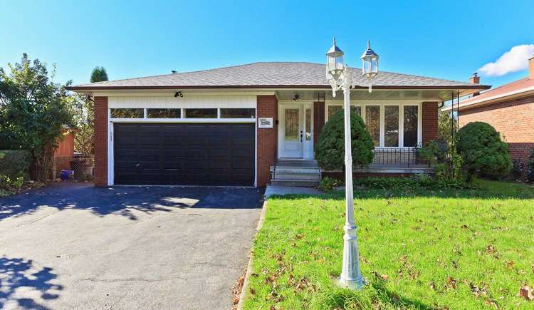
Real Estate Housing Market of Applewood
Demand is steady for Applewood houses of various configurations. The Applewood real estate market has multiple options on offer at diverse pricep points.
Applewood - Location Map and Landmarks
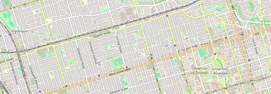
- Commute
- Education
- Health Care
- Shopping & Recreational
- Nearby Cross Streets
- Long Branch Go Station, Toronto 1.93 km
- St Josaphat Catholic Elementary School, Toronto 2.09 km
- Sir Adam Beck Junior School, Toronto 2.31 km
- Christ The King Catholic Elementary School, Toronto 2.63 km
- St Ambrose Catholic Elementary School, Toronto 2.76 km
- Lanor Junior Middle School, Toronto 3.13 km
- James S Bell Junior Middle School, Toronto 3.25 km
- New Haven Learning Ctr For Children, Toronto 3.86 km
- Humber College - Lakeshore Campus, Toronto 4.1 km
- Twentieth Street Junior School, Toronto 4.15 km
- Queensway Christian College And Cathedral, Toronto 4.33 km
- Queensway Health Centre, Toronto 2.4 km
- Mississauga, Peel 3.56 km
- Runnymede Health Care Centre, Toronto 11.08 km
- St. Joseph's Health Centre, Toronto 11.25 km
- Credit Valley, Peel 11.27 km
- West Park Hospital, Toronto 12.35 km
- Centre for Addiction and Mental Health, Toronto 13.62 km
- 80 Workman Way, Toronto 13.74 km
- Jeff, Rose And Herbs No Frills, Toronto 2.4 km
- Cf Sherway Gardens, Toronto 2.85 km
- Top Food Supermarket, Toronto 3.07 km
- Wal-Mart, Toronto 3.61 km
- Bruno'S Fine Foods, Toronto 4.82 km
- Food Basics, Toronto 4.91 km
- Frank & Rose'S No Frills, Toronto 4.95 km
- Lake Shore Boulevard West and Browns Line, Toronto 2.21 km
Last Updated : 1 Day ago

Last Updated : 3 Days ago

Last Updated : 5 Days ago

Last Updated : 6 Days ago

Last Updated : 10 Days ago

Last Updated : 13 Days ago

Last Updated : 13 Days ago

Last Updated : 17 Days ago

Last Updated : 20 Days ago

Last Updated : 67 Days ago

Last Updated : 97 Days ago

Last Updated : 173 Days ago

Last Updated : 17 Days ago

Last Updated : 19 Days ago


